Oroville Dam updates - March 10 - 31, 2023

Talk about anything under the sun! Just remember to be respectful of others.

Oroville Dam updates - March 10 - 31, 2023

Postby Cudedog » Fri Mar 10, 2023 11:44 am

(Scroll down to the 3/31/23 update of this thread for the most current updates)

Don't know what is going on at Oroville this morning.

When I posted yesterday evening, inflow into the dam was 11,264 cfs, outflow was 11,605 cubic feet per second.

Checking this morning, as of 8:00 a.m., inflow has nearly doubled to 21,244 cfs (158,916 gallons per second) and outflow. . . isn't happening. :o Zero. And thus the lake is again rising.

https://cdec.water.ca.gov/dynamicapp/QueryF?s=ORO

Likely this is probably some kind of glitch with the monitoring system up there - it does say at the bottom of the page "Warning! This data is preliminary and subject to revision".

On the other hand. . . let's just say that this (apparent) lack of outflow has definitely got my attention. The last time that outflow was stopped at Oroville dam during a major "rain event" was when the spillway began to crumble and erode into the hillside.

As I say, this is more than likely a glitch of some kind. . . but I'll keep watching.

This again is the photo of Oroville dam, showing the rebuilt spillway:
Image

A photo of the damaged spillway (I'll look around and see if I can find a better one, if you are interested, please check back)::

Image

Anne
Last edited by Cudedog on Fri Mar 31, 2023 11:39 am, edited 13 times in total.
The Stone Wind
Hand Made Hammered Copper & Natural Stone Jewelry
https://www.etsy.com/shop/thestonewind/
User avatar
Cudedog
 
Posts: 2764
Joined: Fri Jan 04, 2013 1:39 pm

Re: Friday, March 10 & Oroville update

Postby Cudedog » Fri Mar 10, 2023 12:05 pm

Another couple of photos. The one on the bottom was taken during the spillway repair project; I include it here so as to give a sense of the size of the thing.

Image

Image

The failure of the spillway (during a major rain event) and the subsequent repair (that took well over a year) was a very major deal here.

Surprisingly, it is sunny ourside this morning. Hopefully, California is dodging the bullet.

Anne
The Stone Wind
Hand Made Hammered Copper & Natural Stone Jewelry
https://www.etsy.com/shop/thestonewind/
User avatar
Cudedog
 
Posts: 2764
Joined: Fri Jan 04, 2013 1:39 pm

Re: Friday, March 10 & Oroville update

Postby MandysMom » Fri Mar 10, 2023 1:16 pm

Second set of photos just won't come up,Anne.
Last night on 11 pm news they said Oroville was increasing outflow today to 16,000 CFS . Haven't watched news to see update for today.
All our big dams are letting water out to allow for inflow as this warmer series of storms brings both rain and snow melt into the system.
We are mch higher than surrounding area, on our own little hill,so the entire city would have to flood to reach us. Rain expected late today, just cloudy right now.
Velda
MandysMom
 
Posts: 4358
Joined: Sat Sep 14, 2013 8:26 pm
Location: Roseville CA

Re: Friday, March 10 & Oroville update

Postby OregonLuvr » Fri Mar 10, 2023 4:53 pm

I can see the pictures. Pretty awesome undertaking when they repaired it.
Karen

Emma Tibetan Spaniel
Image
User avatar
OregonLuvr
 
Posts: 3242
Joined: Fri Jul 18, 2008 9:57 pm
Location: Roseburg, Oregon

Re: Friday, March 10 & Oroville update

Postby BarbaraRose » Fri Mar 10, 2023 4:56 pm

Thanks for the photos for comparison. From the first photo, I was thinking that the spillway doesn't look very big at all. Then seeing the last photo, I realized how huge it really is!

Hope all is under control!
Barbie, Romeow, and Sophie, missing Lola! (and lots of ferrets running around in my heart!)

Image

"Until one has loved an animal, a part of one's soul remains unawakened"
-Anatole France
User avatar
BarbaraRose
 
Posts: 11223
Joined: Sun Dec 06, 2009 8:23 pm
Location: Indio, CA

Re: Friday, March 10 & Oroville update

Postby Bethers » Fri Mar 10, 2023 6:52 pm

I agree that the last picture really shows the size. Wow. I hope the figures have improved.
Beth
“Dare to live the life you have dreamed for yourself. Go forward and make your dreams come true.” ~ Ralph Waldo Emerson ~
"He who treasures the small things in life has found the path to true happiness"
Image
User avatar
Bethers
 
Posts: 17532
Joined: Sat Jul 12, 2008 9:00 pm
Location: Arizona

Re: Friday, March 10 & Oroville update

Postby JudyJB » Fri Mar 10, 2023 7:47 pm

I've been checking Oroville Dam and Napa over the past couple of weeks. Napa had 2.5" of rain in past 24 hours, but Oroville had only 1". I am guessing that the SF and many of the communities near it also had a lot of rain.

When me son first moved to Napa in 1997, he lived in an apartment next to the river and had to move his car once or twice. It was close to downtown Napa, which is at about 20 feet above sea level, and the Napa river that goes through it even has a tide because it is really part of the far North Bay. Their next house, where they lived about 12 years was slightly up the valley to the north and a couple of feet higher, but not much. Their current house is about 60' above sea level, which puts them out of risk, but my son has to cross the Napa river to get from work to home. There are no dams on the river, at least not in Napa County or downriver, but the river does not really have much of a downhill slope to the north bay and the ocean!

Keeping my fingers crossed for California, but glad there is rain to help the drought and fill up the reservoirs.
JudyJB
http://grandmajjb.blogspot.com/
https://2022humongousukadventure.blogspot.com/
"Travel is fatal to prejudice, bigotry, and narrow-mindedness, and many of our people need it sorely on these accounts." Mark Twain.
JudyJB
 
Posts: 7120
Joined: Wed Jul 14, 2010 9:15 pm
Location: Back in Ohio and Michigan for a couple of months.

Re: Friday, March 10 & Oroville update

Postby Cudedog » Sun Mar 12, 2023 12:41 pm

Update: Sunday March 12, 2023

So far, so good so far as Oroville dam and flooding in my area. As most of you probably know, a levee gave way on the Pajaro river, in Monterey County;

https://www.nbcnews.com/news/us-news/second-atmospheric-river-aims-california-federal-emergency-rcna74509

This is about 200 miles south-west of me, and doesn't affect my area.

More rains are coming in, looking at current predictions for water levels on the Feather River near to me it seems that the river will top out at about 55 feet in the next few days, and then go back down. River levels as of this morning are about 46 feet. "Warning Stage" is 65 feet here in my area, so I think we are doing fine.

I am keeping close eye on things here, anyway, as conditions can change - another major atmospheric river is predicted for tonight with heavy rains. And also because my small town is surrounded by levees.

Here is an interesting video of what is going on at Oroville dam - the start of the video shows the floodgates. Take note of the line of tiny yellow dots in about the center of the frame (about 38 seconds in) - these are workers in yellow hazard vests. Again, this will give an indication of the tremendous size of the thing.

https://www.youtube.com/watch?v=BJm0M-3Gh6U&t=4s

This video was posted on the Blancolirio Channel, by Juan Brown. Mr. Brown is a local (Nevada City) pilot who owns his own small aircraft, so he is often able to post some very interesting videos, as he does here. Mr. Brown is also a commercial pilot that flies large cargo planes internationally.

Just a caveat - I sometimes disagree with what Mr. Brown has to say. For example, at the end of this video, I believe that his statements regarding snow hydrology are not totally correct. But, without doubt, Mr. Brown posts interesting and entertaining videos of my extended local area.

These are especially valuable because Mr. Brown is able to fly his own plane over the extended local areas he is talking about. It was one of Mr. Browns videos that I posted a while back regarding the Paradise fire.

Anne
The Stone Wind
Hand Made Hammered Copper & Natural Stone Jewelry
https://www.etsy.com/shop/thestonewind/
User avatar
Cudedog
 
Posts: 2764
Joined: Fri Jan 04, 2013 1:39 pm

Re: Friday, March 10 & Oroville update

Postby JudyJB » Sun Mar 12, 2023 4:52 pm

Very interesting video. It is interesting that the spillway seems to be a bit shorter and the things at the end of it (ccan't remember name) cause the water to break up into a spray and dumps it into a pool. I imagine this is to reduce the erosion at the end of the spillway.

That dam is a terrific example of why bigger is not always better. I can imagine the engineer's speeches as they were looking for approval for the build and funding telling everyone how safe it was because of this terrific spillway!
JudyJB
http://grandmajjb.blogspot.com/
https://2022humongousukadventure.blogspot.com/
"Travel is fatal to prejudice, bigotry, and narrow-mindedness, and many of our people need it sorely on these accounts." Mark Twain.
JudyJB
 
Posts: 7120
Joined: Wed Jul 14, 2010 9:15 pm
Location: Back in Ohio and Michigan for a couple of months.

Re: Oroville Dam updates - March 10 - 13, 2023

Postby Cudedog » Mon Mar 13, 2023 12:29 pm

Good morning.

I have changed the "Subject" of this thread so as to include all of my Oroville Dam updates in one, easy-to-find, location.

As of this morning, March 13, 2023 @ 9:45 a.m. Pacific Time Zone:

The rains here continue. Today and tonight are predicted to have "Heavy Rains", with a chance of thunderstorm, along with high winds.

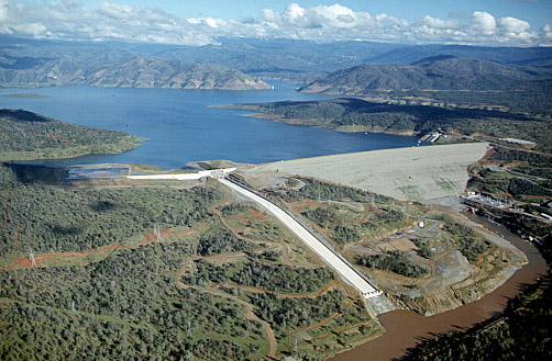
The situation at Oroville Dam has changed a bit, as it always does.

Since yesterday (March 12) the water level in Oroville Dam has risen nearly two feet. As I have said before, Lake Oroville is a huge lake, one of the largest freshwater lakes in the Western United States. For the water level to rise this quickly (with water outflows continuing at the same time!) is pretty amazing.

Current lake level stands at 842.05 feet, and rising. Full pool is 900 feet.

https://oroville.lakesonline.com/Level/

Water releases (outflows) from Oroville Dam have not increased much since my previous update (see above on this thread).

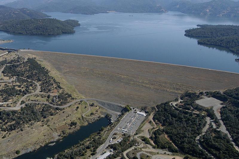
As of the current California Data Exchange Center (California Department of Water Resources):

https://cdec.water.ca.gov/dynamicapp/QueryF?s=ORO&d=13-Mar-2023+09:39&span=12hours

Current water outflows remain low(ish) and fairly constant at 14,869 cfs (cubic feet per second).

Current water inflows have jumped up to an astounding 36,089 cfs (cubic feet per second). Converting cfs to gallons, this translates to 269,964 gallons of water flowing in to Oroville Dam per second.

This means that there are well over one quarter million gallons of water, per second, coming in to Oroville Dam.

That is a truly tremendous amount of water. And with the continuing heavy (and warmer) rains, and with these rains falling over (and thus melting) the lower-elevation Sierra snowpack (this rain will still fall as snow over the higher elevations) the rate of inflow is expected to increase.

I assume that the rate of outflow will also be increased, seeing the mis-match between current inflow and outflow, but this has not yet happened.

Of course, as outflows into the Feather River are increased, the water levels in the Feather River will also unavoidably rise. This will inevitably put water up on the levees.

There has been a lot of work (funded by a property tax bond added to local property tax bills), over the last few years. I feel confident that the levees will hold - but I am not letting down my guard, and am keeping a close eye on river levels. My house is about a mile from the Feather River, with the levees between me and the river.

Levees are kind of like earthquakes - if the ground shakes hard enough, long enough, even "earthquake proof" buildings will fall. If it rains hard enough, and long enough, and the snow melts fast enough, and Oroville Dam is forced to release ever more water, and the river levels come up on the levees - well, I'm sure you get the picture. All bets are off.

Nothing is 100%.

This "water on the levees" thing is a bit difficult to explain, so here are a couple of photos to help illustrate what I am talking about:

This is not a photo of a levee in my area, but this photo is very representative of what we have here. This photo shows "water on the levee". In normal times water likely wouldn't even show in this photo, because the water level would be so low it would be below the bottom of the photo. Note that on the right side of the photo the water level is getting very close to the top of the levee. Note ALSO that the water level in this photo appears to be ABOVE the ground level of the homes behind the levee. This is a very dangerous situation.

Image

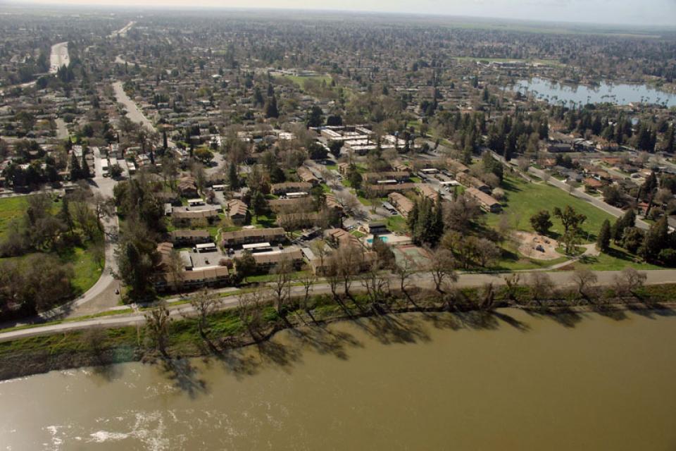
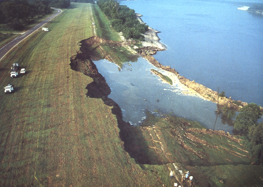
This is next photo is also not a photo of a levee in my area, but this photo is very representative of (again) what we have here - and similar to situations we have had here in the past. This photo shows a badly eroding levee, on point of failure.

And, yes, levees have failed in my area in the past.
Image

I have contacted a friend that lives in the (San Francisco) bay area. I evacuated to her house for several days in 2017 when it was feared that the emergency spillway at Oroville Dam was on point of failure. Me and about two-hundred-thousand of my closest friends also evacuated in this emergency.

My friend has invited me to "visit" should conditions here change.

Once one has experienced an evacuation emergency, one never forgets the experience. Which is why I continue to remain alert.

Thanks for reading. I welcome your comments and questions.

Anne
The Stone Wind
Hand Made Hammered Copper & Natural Stone Jewelry
https://www.etsy.com/shop/thestonewind/
User avatar
Cudedog
 
Posts: 2764
Joined: Fri Jan 04, 2013 1:39 pm

Re: Oroville Dam updates - March 10 - 13, 2023

Postby JudyJB » Tue Mar 14, 2023 1:36 am

Very good information, Anne. I have a couple of questions, however.

1) Do you still have your trailer? Or was it a motorhome? And if so, it is stored somewhere higher than you would expect the river to flood to? I am wondering if you could evacuate to it, and drive it somewhere out of danger. If you still have it, it would be a lifeboat, maybe even with bedding, towels, basic food items, etc.

2) Also, I am not terribly familiar with California, but after the Feather River leaves the dam, where does it go?

3) Are there other dams upstream or downstream on the Feather River? Or is it just the one gigantic lake?

4) And you probably cannot answer this, but when it the snow expected to start melting? It is already mid-March, so I am wondering when that will happen.

Thanks
JudyJB
http://grandmajjb.blogspot.com/
https://2022humongousukadventure.blogspot.com/
"Travel is fatal to prejudice, bigotry, and narrow-mindedness, and many of our people need it sorely on these accounts." Mark Twain.
JudyJB
 
Posts: 7120
Joined: Wed Jul 14, 2010 9:15 pm
Location: Back in Ohio and Michigan for a couple of months.

Re: Oroville Dam updates - March 10 - 13, 2023

Postby MandysMom » Tue Mar 14, 2023 3:06 am

Judy
Yes Anne's RV was/is a travel trailer, but she also built out her van as a comfortable nest as well.
The Feather River is 185 miles long from its headwaters in Plumas in northern California, to it's end, after leaving Lake Oroville, ending at the Sacramento River near Verna, north of Sacramento (the city).
The Upper Fork of Feather River has 3 dams/reservoirs, 5 power houses,tunnels and pen stocks connecting the reservoirs to the powerhouses.
Snow is already melting from rain and warmer temperatures at elevations as high as 5000 ft and below. There is a lot of snow up there, and more to come over next 24-48 hours! Crews have been working to cut channels to allow melt to run down instead of flooding houses and businesses.
Folsom Dam/Reservoir, just 7 miles from my home, is at about 57% and rising with outflows at 18,000 CFS as of yesterday and inflow at 19,000 CFS. With a 220% snowpack, it will be a balancing act to prevent overfilling, while not flooding downstream. Folsom Dam was built as a flood control dam and each year we hear people whine about water being let out, but I trust experts to balance flow, while maintaining water through our Delta, which keeps salt water from backing up and killing fish and damaging farmland.
Hope that answers your questions.

Velda
MandysMom
 
Posts: 4358
Joined: Sat Sep 14, 2013 8:26 pm
Location: Roseville CA

Re: Oroville Dam updates - March 10 - 13, 2023

Postby Cudedog » Tue Mar 14, 2023 8:26 pm

Update March 14, 2023 @ 5:00 p.m.

Thanks for posting the info, Velda.

Judy, I have a travel trailer that I keep in an indoor-type storage unit (its an old converted warehouse - there might be a hundred RVs stored in there). There is an ordinance here in my town against keeping trailers on the street or in one's driveway. To do so is to be ticketed.

As Velda said, my van is set up as a camper (with a bed), although my Jayco (trailer) is a lot more comfortable. The problem being if there was an emergency, I would need to drive to the storage place (and it is only open during daylight hours) have it brought out of the warehouse, then hookup. This would all take a considerable amount of time, even though the place is only about 2 miles away.

Should an emergency happen, I would just take off in my van, and not bother with the trailer. Me and about 50,000 other people will all be trying to get out of town at the same time (during the 2017 evacuation it was total chaos). Also, if there was an emergency (like maybe a levee problem) there is no "high ground" here. The nearest high ground is about ten miles away.

A bit more about Lake Oroville (nice graphic at the link, unfortunately the image is too large to put within a post - but click on the link, it is well worth a visit):

https://treesource.org/wp-content/uploads/2017/03/Upper-Feather-River-Watershed-graphic.jpg

"The upper Feather River Watershed is roughly the size of Yellowstone National Park and fills the principal water storage facility for the California State Water Project. . . the Feather River provides over 25% of the State's drinking water. . . the North Fork of the Feather River provides roughly 10% of California's hydroelectric power."

Water level at Lake Oroville currently (March 14, 2023 @ 5:00 p.m.) is at 848.75 feet, an increase of almost four feet from 7:00 a.m. (845.88) this morning.

https://cdec.water.ca.gov/dynamicapp/QueryF?s=ORO&d=14-Mar-2023+18:05&span=12hours

Current outflow (March 14, 2023 @ 5:00 p.m.) is 15,581 cfs (cubic feet per second). Current inflow is a tremendous 72,806 cfs (1 cubic foot = 7.48 gallons). Thus, as of 5:00 p.m. current inflow is an astonishing 582,029.3 gallons per second - well over a half million gallons of water coming into Oroville dam every second!

52 feet to go until the dam is full.

Here is a graphic showing the Oroville Dam watershed (look for Oroville Dam/Lake Oroville on the lower left. All of the watershed for Lake Oroville is in the Sierra mountains, from foothills to 10,000 foot peaks.

https://www.plumascounty.us/DocumentCenter/View/11641/FR_Map?bidId=

Looking at rainfall totals in the city of Oroville (Oroville is a valley town) doesn't have much meaning - the dam is above the city of Oroville, in the foothills, and rain falling on the city of Oroville doesn't go into the dam.

The rain/snow that drains into Oroville falls in the mountains - where precipitation is always significantly higher.

Watershed Statistics

1. Watershed Size: 3,200 square miles
2. Watershed Length: ~60 miles (Sierra Crest to Oroville)
3. Average Annual Precipitation: 12 inches (eastside) to 70 inches (westside)

Elevation:
Highest: 10,000 ft.
Lowest: 2,000 ft.

Here is another view of Oroville Dam, with the Hyatt Power Plant on the lower right (er. . . yes, the power plant is underground. This is the power plant parking lot):

Image

So far so good!

Anne
The Stone Wind
Hand Made Hammered Copper & Natural Stone Jewelry
https://www.etsy.com/shop/thestonewind/
User avatar
Cudedog
 
Posts: 2764
Joined: Fri Jan 04, 2013 1:39 pm

Re: Oroville Dam updates - March 10 - 14, 2023

Postby JudyJB » Wed Mar 15, 2023 9:57 pm

As of right now, March 15 9:00 pm MST, Lake Oroville level is 856.96, which means it has gone up 7 feet since yesterday, per the website.

https://oroville.lakesonline.com/Level/

Sounds like they are not dumping enough water!
JudyJB
http://grandmajjb.blogspot.com/
https://2022humongousukadventure.blogspot.com/
"Travel is fatal to prejudice, bigotry, and narrow-mindedness, and many of our people need it sorely on these accounts." Mark Twain.
JudyJB
 
Posts: 7120
Joined: Wed Jul 14, 2010 9:15 pm
Location: Back in Ohio and Michigan for a couple of months.

Re: Oroville Dam updates - March 10 - 14, 2023

Postby Cudedog » Thu Mar 16, 2023 3:04 am

JudyJB wrote:As of right now, March 15 9:00 pm MST, Lake Oroville level is 856.96, which means it has gone up 7 feet since yesterday, per the website.

https://oroville.lakesonline.com/Level/

Sounds like they are not dumping enough water!


Thanks, Judy. You are correct about the rapid rise in water levels at Oroville Dam.

It is worrisome, but probably ok. My understanding is that the intent is to fill the dam all the way to the top - nine-hundred feet - this year. This is, of course, fine by farmers, recreators, and PG&E - but "finger-nail biting time" for those (like myself) that live directly downstream of the dam on the Feather River.

According to the California Department of Water Resources:

https://cdec.water.ca.gov/dynamicapp/QueryF?s=ORO&d=16-Mar-2023+00:25&span=12hours

As of midnight, Pacific Time, the water level has come up another foot in just a couple of hours since you last posted.

Current inflow is 49,331 cfs, outflow is less than half of the inflow at 21,210 cfs.

I think it was you that asked a few posts ago whether Lake Oroville was just "one giant lake" or if there were other dams on the Feather River. Velda answered this question very well - thanks again, Velda.

I would like to add that the entire system is sometimes called "The Feather River Stairway of Power", because of the many dams, and additional power plants on the upper branches of the Feather River (in the Sierra mountains above Oroville dam).

The Feather River "Stairway of Power" is mostly owned by PG&E (Pacific Gas & Electric - the same public utility blamed - and fined - for many recent California wildfires and gas explosions).

"Fun Fact" (or maybe not-so-fun for the hundreds of thousands of people living near the Feather River) is that if any of the many dams (click on the link below for a brief description of each) in the upper Feather River watershed should fail this would also send further massive amounts of water (from any failed dam/s) on down into Lake Oroville.

"Feather River Stairway of Power":
https://www.wplives.com/frc/stairway_of_power.php

But. . . so far so good. . . biting my nails, but keeping my fingers crossed. LOL, kind of difficult to do both of these things at the same time!

Thanks, Judy.

Anne

Hyatt Powerplant at Oroville Dam
Image
The Stone Wind
Hand Made Hammered Copper & Natural Stone Jewelry
https://www.etsy.com/shop/thestonewind/
User avatar
Cudedog
 
Posts: 2764
Joined: Fri Jan 04, 2013 1:39 pm

Next

Return to General Talk

Who is online

Users browsing this forum: No registered users and 2 guests

cron